Garmin
Alpha XL - Rugged Dog Tracking GPS Navigator
Alpha XL - Rugged Dog Tracking GPS Navigator
Couldn't load pickup availability
PRE-ORDERING IS AVAILABLE
Track your pack from your truck. Monitor and recall your dogs in the field with the Alpha XL dog tracking GPS navigator. It shows you the way, on- or off-road, and pairs directly with your compatible dog collars via VHF radio — so you can follow up to 20 dogs from up to 9 miles away. See the location of your dogs in real time on the large 10" touchscreen display. To reach your hunting grounds, get turn-by-turn navigation for streets, unpaved roads and trails. Once in the field, off-road tools include satellite imagery, high-definition elevation maps, adventure roads and trails content, a 3-axis compass and more. Deliver training commands — from 18 levels of stim, tone and vibe — to your paired training-enabled dog collars from the touchscreen while viewing each dog’s distance traveled, average speed, barks per minute, geofencing alerts, collar battery level and other settings
HUNTING/TRACKING FEATURES
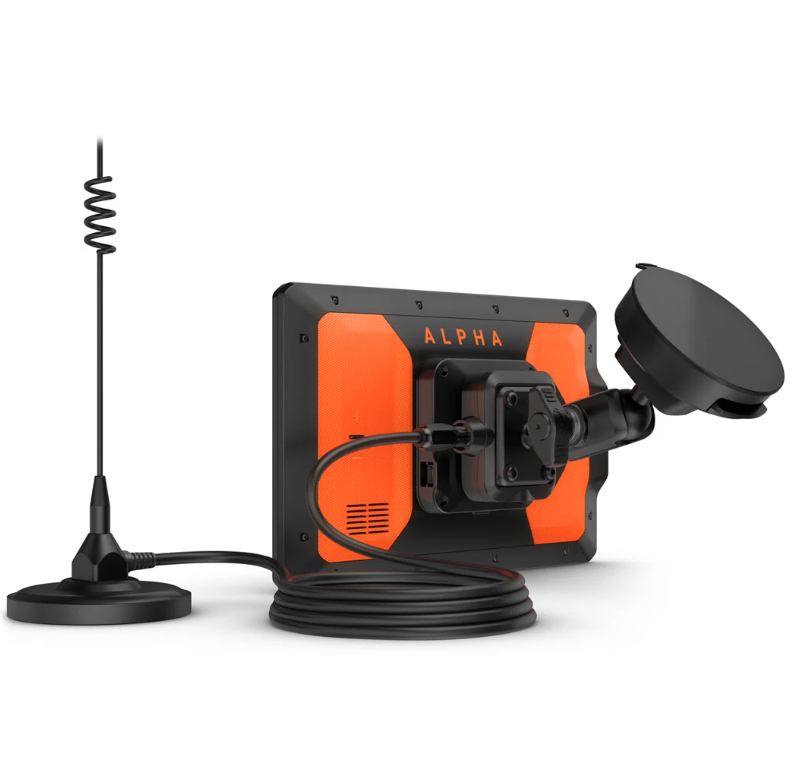
IN-VEHICLE TRACKING
View dog positions overlaid on topo contours or satellite image views.
WIRELESS CONNECTION
Tracker works on or off the in-vehicle dock — connecting wirelessly within 10’ for up to 2 hours.
18 LEVELS OF TRAINING
Customize commands with momentary and continuous stim plus different levels of tone or vibration.
DOG LIST/GROUP MANAGEMENT
Store up to 250 dogs in your list, and manage active groups.
PRO VIEW COMPASS
Display shows which direction and how far away dogs are — and when a dog is “treed” or “on point.”
COLLAR MONITORING
See battery level, communication state and more for paired collars.
LOCATION AND GEOFENCING ALERTS
Know where your dogs are, and get an alert if they move outside a designated area1.
DEVICE INTEGRATION
Enjoy wireless connectivity with a full range of compatible Garmin handhelds and dog collar devices.
BACKWARD COMPATIBLE
Easily pair the device to select T and TT™ series collars.
NAVIGATION FEATURES
MULTI-GNSS SUPPORT
Access multiple satellite systems to track your pack in more challenging environments than GPS alone.
MAPS FOR ON- AND OFF-ROAD
Get topo and street maps of North America, U.S. Forest Service roads and trails, and more.
TOPOACTIVE MAPS
See terrain contours, elevations, summits, parks, coastlines, rivers, lakes and more.
ABC SENSORS
Outdoor sensors include altimeter, barometer and 3-axis electronic compass for rugged-terrain guidance.
OUTDOOR MAPS+
Subscribe to Outdoor Maps+ to view public land information, enhanced topo maps, landowner names